 Driving on the Red Mountain 202 Freeway, between Val Vista Drive and Gilbert Road, you pass under a $2.7 million overpass with no freeway entrances or exits—Mesa’s Bridge to Nowhere.
Well, not exactly nowhere. It will lead you to the end of the Old Lehi Trail, the route a band of Latter Day Saints (Mormon) pioneers forged in 1877, led by Daniel Webster Jones, who left St. George, Utah, at the urging of Brigham Young, to establish a settlement further south, according to historical information from the Sharlot Hall Museum in Prescott.
No remnants of the old Lehi settlement remain except a marble monument on the trail commemorating its founding. If you want to get a feel for what early pioneers experienced, however, turn north off McDowell Road onto Lehi Road, and head downhill off the mesa (yes, Mesa is on a mesa).
As you descend toward the Salt River bottom, you will get a glimpse of what the area might have looked like back then. There are fabulous vistas of the surrounding mountain and the river channel, canals and some older buildings among the few remaining citrus groves—what used to be a major Arizona corporation Citrus growers still offer their wares at the Orange Patch and other fruit stands amidst the trees.
Continue toward the river, and the bridge is on your right. This so-called Bridge to Nowhere was added about 10 years ago, during the construction of the 202 Freeway, to provide access to groves for local farmers who gave up land for the project.
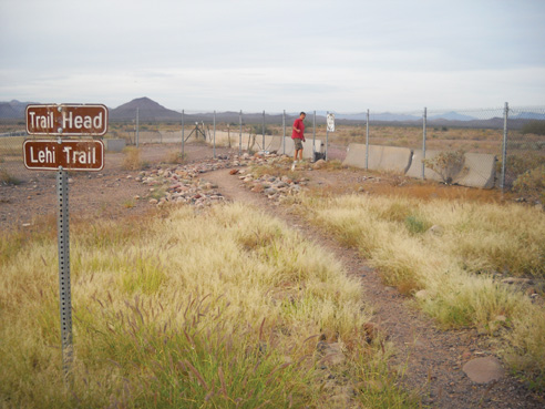
The only other public access to the bridge is to turn west off Val Vista Drive at Thomas Road. Thomas Road then crosses over the huge, mostly unused freeway bridge, and dead-ends into a citrus grove surrounded by a chain-link fence and no-trespassing signs. To find the Lehi Trail, cross over the bridge and turn right onto the dirt road, which ends in a dirt parking area. No motorized vehicles are allowed on the trail, which begins just to the north. Signs mark the way.
The trail, which was a major route for pioneers and extended into the Superstition Mountains, has been only partially reconstructed, and now is used by hikers, bikers and horseback riders. From the bridge, you can travel for a mile or two along the Salt River. With nothing to block the view, there are panoramic vistas of all the surrounding mountains.
About halfway along the trail is the white pyramid-shaped monument. According to news reports of the time, the memorial has been rescued twice by Lehi citrus grower Art Freeman, owner of the Orange Patch fruit stands. During the1970s floods, Freeman moved the monument out of the path of rising floodwaters, in the middle of the night, shortly before a bank washed away.
As you travel east, back toward Val Vista Drive, you pass by Tyler Farms, a grass-fed cattle ranch, and horseback riding and boarding facility. Behind the ranch is a network of canals and waterways, attracting various waterfowl.
A short distance further takes you back to the South Canal trail, which runs under the freeway, back to McDowell Road. The unpaved trail east also follows the South Canal all the way to the CAP Canal and the Verde River.
The Lehi Trail to the left also continues on from here, but, according to James Hash, bicycle and pedestrian planner for the City of Mesa, the trail winds along the border of the Salt River Pima-Maricopa Indian Reservation, and is not reconstructed or well-marked and does not show up on trail maps. Those who want to try following it should take care to avoid trespassing on tribal lands, James advised.
For more information, or to get maps of Mesa’s network of trails, contact the City of Mesa Transportation Department at (480) 644-2160.

